Explore the best places
Country in Portugal
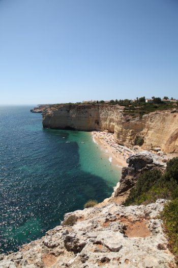
Percurso dos Sete Vales Suspensos
- country
Praia do Vale de Centianes
8400, Lagoa
This route, which stretches over 5.6 kilometers, follows the winding lines of the cliffs located between Praia de Vale Centianes and Praia da Marinha. The route runs along a line of cliffs, interrupted by some lines of water, which flow above sea level, giving rise to "hanging valleys". Along the route, the visitor has the help of almost two dozen information panels, explaining the route and identifying the main points of interest.
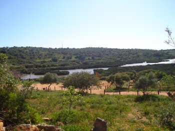
Parque Municipal do Sítio das Fontes
- country
Parque Municipal do Sítio das Fontes
8400, Estômbar
A place of rare ecological-environmental beauty, stretched along the left bank of the Arade River. The park occupies an 18-hectare plot of land, where different environments are found: salt marsh, marshland, scrubland, a lagoon, agricultural areas, flats and watercourses. Nearby there are ancient traces of human activities such as water mills. It has a reception building, guard's house, restrooms, open-air amphitheater, picnic area, maintenance route and a pier.
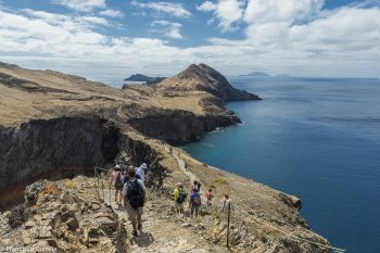
Ponta de São Lourenço
- country
ER109
9200, Machico
Ponta de São Lourenço is a peninsula classified as a Partial Natural Reserve, and the islet of Desembarcadouro as an Integral Natural Reserve, both integrated into the Madeira Natural Park and on the list of Sites of Community Interest in the Natura 2000 Network. It consists of some volcanic hills of recent origin and steep and very high rocky cliffs that fall steeply into the sea, featuring some caves and pebble coves. Along the coast there are two main islets: Desembarcadouro and Farol. There are some endemic plants and protected animal species such as the sea lion.
Reserva Natural do Paúl do Boquilobo
- country
Estrada do Concelho - EM570
2150-045, Azinhaga
In the Tagus marshes, and covering the Municipality of Golegã, next to the Almonda River, Paul do Boquilobo is an alluvial plain of swamps of great faunal and floristic importance. Here the water rises and falls, is still or moving and the land area increases and decreases depending on the season. It all depends on the flow of the Tagus and Almonda rivers. It is a privileged nesting site for numerous species of water birds (cattle heron and white heron), in a landscape dominated by willows (white and black) and aquatic plants (Caniço).
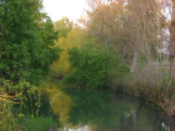
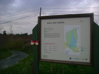
Paúl do Taipal
- country
Paúl do Taipal
3140, Montemor-o-Velho
This space, together with the Arzila and Madriz marshes, represents one of the last examples of this type of wetland in the Central Region. It is divided into the swampy area itself and a surrounding area, where there are agricultural and forested areas. It extends over 233 hectares, with a maximum altitude of 25 meters.
Gruta do Escoural
- country
EM370
7050, Escoural
Cave that served as the community's residence and burial site, with traces of occupation since the Middle Paleolithic. It features cave paintings and engravings from the Upper Paleolithic and late Neolithic. It has a gallery/room type configuration, consisting of 30 galleries with rooms, corridors, ramps and chambers.
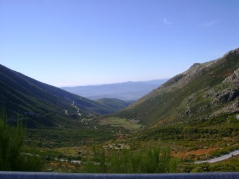
Serra da Estrela
- country
EN339
6215, Unhais da Serra
There are those who say that it has more charm in winter due to the additional beauty that the snow provides, but there are lots of interesting reasons to also visit it in the warmer months. Starting with the protected area of the Serra da Estrela Natural Park, with a rich fauna and flora, and ending at Torre, the highest point in mainland Portugal. On foot or by car, there is a lot to explore. Another essential reference is Serra da Estrela Cheese.
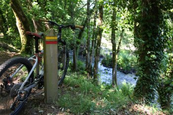
Trilho Interpretativo da Ribeira de Covas
- country
Serra de Covas
4920, Covas
This pedestrian route crosses the Covas mountain range and passes by Azenha do Pagade, over the Coura river. With a length of around 4.5 kilometers, it passes through green areas of great natural beauty. With practically no unevenness, this route is characterized by its proximity to the Minho and Coura rivers, along which the richness of the area's flora does not go unnoticed, with its native trees offering shade to walkers. Its fauna is equally rich and worthy of mention, from birds to otters. You will also pass through part of an old area that carried water from the dam …
Percurso Pedestre Pinelo-Corane-Azimute
- country
EN218-2
5230, Vimioso
Pedestrian route of approximately five kilometers.

Serra da Freita
- country
Serra da Freita
3730, Arões
Serra da Freita is part of the Gralheira Massif, together with Serra da Arada and Serra do Arestal, reaching its maximum altitude at 1085 meters at Pico de São Pedro Velho, and extending through the municipalities of Arouca, São Pedro do South and Vale de Cambra. There you will find natural riches such as the Frecha da Mizarela waterfall, 75 m high, and the Pedras Parideiras, a geological phenomenon that can only be observed in Russia. These are a type of stones that are “born” from a mother rock of granite origin, and which symbolize fertility in the region’s popular …