Explore the best places
Country in Portugal
Passadiços do Gresso
- country
EM328, 1
3740-183, Sever do Vouga
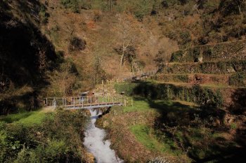
These walkways are on the Gresso trail, in Sanfins, Rocas do Vouga. In the surrounding area you will find bridges, small waterfalls and sides, with extensive native vegetation. The access point to the walkway area is located on the Gresso River bridge, north of Sanfins.
Rota dos Cântaros e Cantos
- country
Sardoal
2230, Sardoal
This route covers 34 sources spread across five municipalities: Sardoal, Constância, Gavião, Mação and Abrantes. Seven are located in Sardoal: Fonte Chafariz das Três Bicas, Fonte Férrea, Fonte da Pena or Penha, Fonte da Rua do Vale, Fonte Velha, Fonte Nova and Fonte dos Mouros.
Dunas da Torreira
- country
Dunas da Torreira
3870, Torreira
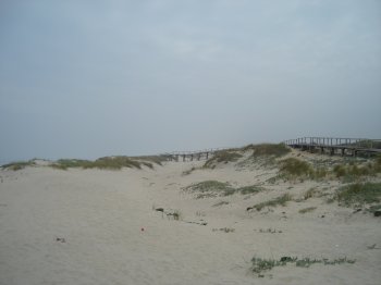
Preserved dunes, with warnings posted about the precautions to be taken with this type of resource.
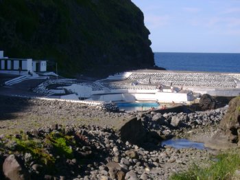
Piscina Natural da Boca de Ribeira
- country
Piscina Natural da Boca de Ribeira
9630, Nordeste
The Boca de Ribeira Natural Swimming Pool is characterized by its clear waters, created by volcanic activity and the action of the sea. The space is well-used and restored.
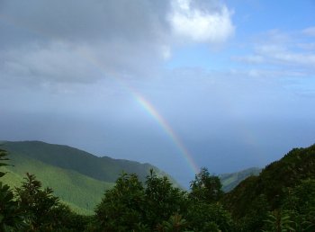
Pico Bartolomeu
- country
EM1038
9630, Nordeste
Peak located in Serra da Tronqueira, allowing you to see a surprising landscape that goes from the slopes dotted with hydrangeas to the sea.
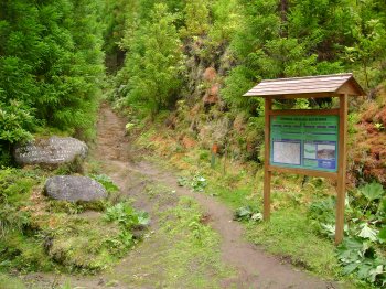
Trilho Pedestre da Lomba da Fazenda (PRC31)
- country
Boca da Ribeira
9630, Lomba da Fazenda
Circular pedestrian route that starts and ends in front of the Church of Nossa Senhora da Conceição, in Lomba da Fazenda. It is approximately seven kilometers long and lasts two hours. Along the trail you will pass the Nordeste campsite, the Boca da Ribeira bathing area, the Pelado Endémicas Park and the Morgada Park.
Trilho Pedestre Algarvia - Pico da Vara (PR7)
- country
Santo António de Nordestinho
9630, Santo António de Nordestinho
Pedestrian route with a length of around ten kilometers and a medium degree of difficulty. Along the way you can enjoy the beauty of the surrounding landscape, coming into full contact with nature. To follow this trail you will need to obtain authorization from the forestry services.
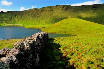
Zona de Proteção Especial da Costa do Caldeirão
- country
Estrada do Caldeirão
9980, Corvo
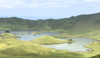
This protected area has around 777 hectares and a maximum altitude of 720 meters, including most of the island's coastline and its islets, as well as the Caldeirão volcano. It is home to important communities of endemic flora and fauna species, as well as migratory birds.
Morro dos Homens
- country
Estrada do Caldeirão
9980, Corvo
This elevation is part of the central volcano of Corvo Island, being its highest point.
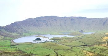
Trilho Pedestre Caldeirão - Ponta do Marco (PR2)
- country
Estrada do Caldeirão
9980-028, Vila do Corvo
This route starts at Miradouro do Caldeirão, ends at Cancela do Pico and lasts approximately 4 hours. One thing to take into account is that it is a route that can only be done with the help of a guide. After passing by Morro dos Homens, to the left of the main road, at 718 meters above sea level, follow, further ahead, Espigãozinho. It's the end of the road and the beginning of the adventure. At the bottom, there is the "cauldron", a large sinking crater 3.7 km in diameter and 300 meters deep. Two irregularly shaped lagoons and small …