Explore the best places
Country in Portugal
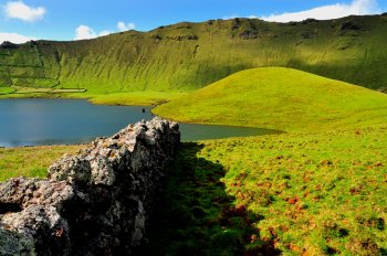
Zona de Proteção Especial da Costa do Caldeirão
- country
Estrada do Caldeirão
9980, Corvo
This protected area has around 777 hectares and a maximum altitude of 720 meters, including most of the island's coastline and its islets, as well as the Caldeirão volcano. It is home to important communities of endemic flora and fauna species, as well as migratory birds.
Morro dos Homens
- country
Estrada do Caldeirão
9980, Corvo
This elevation is part of the central volcano of Corvo Island, being its highest point.
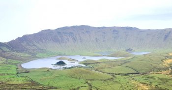
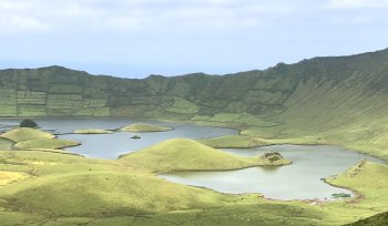
Trilho Pedestre Caldeirão - Ponta do Marco (PR2)
- country
Estrada do Caldeirão
9980-028, Vila do Corvo
This route starts at Miradouro do Caldeirão, ends at Cancela do Pico and lasts approximately 4 hours. One thing to take into account is that it is a route that can only be done with the help of a guide. After passing by Morro dos Homens, to the left of the main road, at 718 meters above sea level, follow, further ahead, Espigãozinho. It's the end of the road and the beginning of the adventure. At the bottom, there is the "cauldron", a large sinking crater 3.7 km in diameter and 300 meters deep. Two irregularly shaped lagoons and small …
Trilho Pedestre da Cara do Índio (PR1)
- country
Rua Jogo da Bola
9980-024, Corvo
The route follows old canals flanked by stone walls and heads towards the coast. Along the way you will find ancient shelters, interesting geological formations and beautiful wild cedars.
Monte de Nossa Senhora da Graça
- country
Rua da Senhora da Graça
4880, Vilar de Ferreiros
Monte da Senhora da Graça is distinguished from other elevations of the Alvão/Marão mountain set by its steepness (known for the famous finishes of the Volta a Portugal by Bicycle) and because it is an elevation isolated from the others, clearly visible from the center of Mondim of Basto. It has great views from 940 meters above sea level, a sanctuary and a restaurant.
Parque Natural do Alvão
- country
Lugar do Barrio - Sítio do Retiro
4880-164, Mondim de Basto
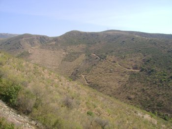
Bounded to the north by Minhéu and to the south by Padrão de Teixeira, covering a length of 50 km, this park covers the municipalities of Mondim de Basto and Vila Real and the Serras do Alvão and Marão. These are separated by Alto do Velão, 914 meters above sea level. In fact, the Park never drops below 900 meters in altitude, constituting, along with the Serra do Gerês, a scenic barrier between the coast and the interior. On the eastern edge of the Park, at 1339 meters above sea level, stands Alto de Caravelas, the highest point of the …
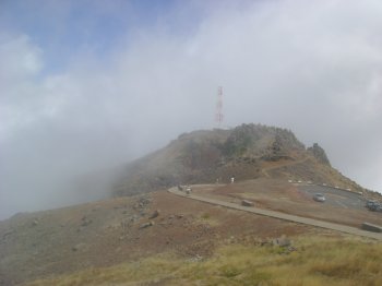
Pico do Areeiro
- country
ER202
9230, Santana
It is the second-highest peak on the island, with an altitude of 1818 meters. Access can be done by car, with a cafe and a hotel at the top. From the peak you can see a stunning landscape and, when the weather is good, you can see the neighboring island of Porto Santo.
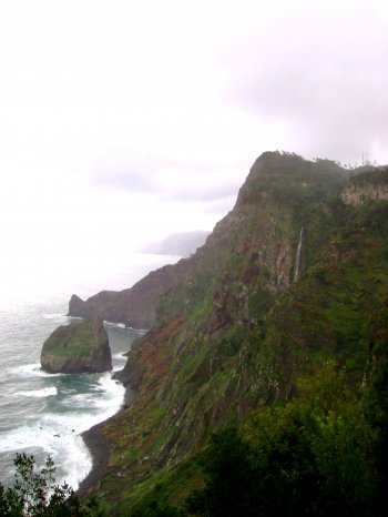
Reserva Natural do Sítio da Rocha do Navio
- country
Sítio da Parlatório
9230-105, Santana
Natural reserve integrated into the Madeira Natural Park, with a total area of 1710 hectares and a total length of 6259 meters. It is exclusively marine, meaning it also covers the seabed up to 100 meters and the islets of Rocha das Vinhas and Viúva, or Rocha do Navio. This protected area was created in 1997 at the will of the local population, with the aim of protecting fishing and maritime resources against indiscriminate fishing, often using explosives. Of its natural, scientific and cultural wealth, its botanical heritage stands out, with several species of endemic flora on the cliffs, among …
Serra do Reboredo
- country
Serra do Reboredo
5160, Moncorvo
Small rock mass located east of the Sabor River, close to Torre de Moncorvo. It measures around ten kilometers in length, reaching its maximum altitude in Fraga do Facho. It is a very wooded mountain range, which invites you to take beautiful walks among the dense vegetation. Here we find, in addition to the Lusitanian oak, wild chestnut trees, beeches, black trees and pines. In other times, the bush hid several big game animals such as bears, wild boars and deer and the town's population went here to stock up on firewood. Reboredo preserves, in its subsoil, very rich deposits …
Serra de Santa Helena
- country
Serra de Santa Helena
3610, Tarouca
Located in one of the foothills of the Serra de Montemuro, a Sanctuary stands out at the top of the Serra de Santa Helena. From this point you can see a beautiful landscape with the town of Tarouca at the foot.