Explore the best places
Country in Portugal
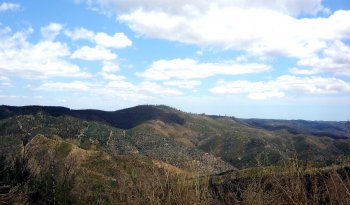
Serra de Monchique
- country
Serra de Monchique
8550, Fóia
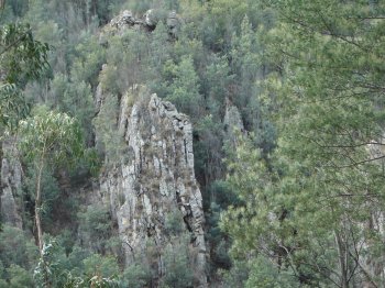
This mountain range belongs to the Antigo Massif , south of the Tagus and divides the Alentejo from the Algarve. It is located between the Espinhaço de Cão and Caldeirão mountains. It has a maximum altitude of 902 meters (reached in Foia) and measures 30 km in length.
Percurso Pedestre Olhar sobre a Foz (PR3)
- country
São Matias
6050, São Matias
Walking route of 5.75 kilometers and expected to last 2 hours. It begins at the Velada Hydroelectric Power Station, built in 1935; it runs alongside Ribeira de Nisa. After passing the point where it crosses the Tagus, the most difficult point of the route is reached, as the eucalyptus trees become denser and the climb is steep, but it will be worth the effort, as, at the top, there will be an incredible panoramic view over the Nisa and the Tagus. The difficulty level of this tour is easy.
Penedo de Castro
- country
Penedo de Castro
3360, Penacova
Granite block located in the upper part of the village. It started out being called Penedo do Cheira, as it was located above the town of Cheira, but was later given the name Penedo de Castro, in 1908, in honor of the writer Augusto Mendes Simões Castro. This location offers an impressive panoramic view over Penacova.
Livraria do Mondego
- country
Livraria do Mondego
3360, Penacova
Grandiose rock formation made up of Ordovician quartzites, located on the banks of the Mondego River. Its name probably comes from the arrangement of the rocks, which seem to suggest a shelf with books.
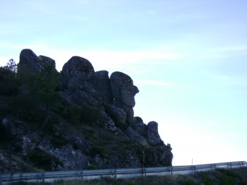
Cabeça do Velho
- country
EN232
6290, Gouveia
Granite rock located at about 1500 meters of altitude, known for resembling a head in profile.
Parque Natural de Montesinho
- country
Portelo
5300-544, França
With around 75,000 hectares, it is one of the largest protected natural areas in Portugal and a must-see for anyone arriving in this region where nature has been very generous. The Serra de Montesinho is characterized by its rounded hills and the valleys the Sabor, Maçãs and Baceiro Rivers. The fauna is varied and rich, with emphasis on the presence of wolves, deer, roe deer, nesting birds, amphibians and reptiles. There are signposted walking paths that are a great way to get in touch with the vast biodiversity.
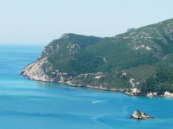
Serra da Arrábida
- country
Serra da Arrábida
2900, Setúbal
Located in the Natural Park of the Arrábida Hill, it overlooks the Atlantic Ocean. It spreads from the Palmela hillock to the Cape Espichel and it is 35 km long, 6 km wide in average, and reaches its peak at the Alto do Formosinho. Occupied since the days of old, the roman presence may be seen in the tanks that the romans used for salting the fish. A space with landscapes of great beauty that includes woods and beaches alike. It is extremely rich in terms of animals and plants, with local species, as well as in architectural terms, namely …
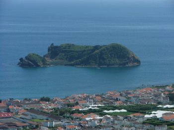
Ilhéu de Vila Franca do Campo
- country
Vila Franca do Campo
9680, Vila Franca do Campo
Located about a kilometer from the coast, the islet and the sea surrounding Vila Franca do Campo are a natural reserve. Its shape is due to the action of marine erosion on a volcanic cone. Between the months of June and September, there is a boat connection between the port of Vila Franca and the islet, so that people can enjoy the natural pool with clear waters.
Trilho Pedestre Praia - Lagoa do Fogo (PRC2)
- country
Caminho Ribeira da Praia
9680, Água de Alto
This route starts in Ribeira Grande, passing by the geothermal station and Caldeira Velha, then climbing to the viewpoint that offers a magnificent view over this famous lagoon and, finally, descending to its banks. It is approximately six kilometers long.
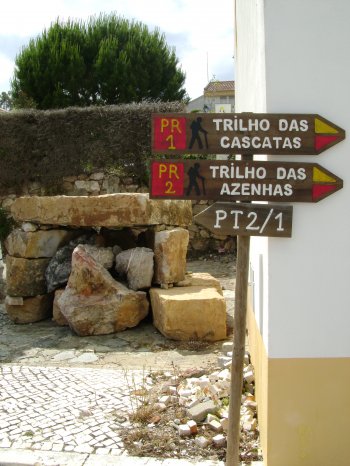
Trilho das Cascatas (PR1)
- country
Vila de Rei
6110, Vila de Rei
Circular pedestrian route with approximately ten kilometers long, starting and ending in Vila de Rei. It goes through Ribeira do Lavadouro, Ribeira do Vale Feito and Ribeiro da Vila, highlighting the various waterfalls and corners of great natural beauty, present in the surrounding area along the way. You can also observe a great diversity of fauna and flora.