Explore the best places
Results for Serra+da+Estrela in Portugal
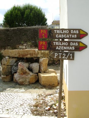
Trilho das Cascatas (PR1)
- country
Vila de Rei
6110, Vila de Rei
Circular pedestrian route with approximately ten kilometers long, starting and ending in Vila de Rei. It goes through Ribeira do Lavadouro, Ribeira do Vale Feito and Ribeiro da Vila, highlighting the various waterfalls and corners of great natural beauty, present in the surrounding area along the way. You can also observe a great diversity of fauna and flora.
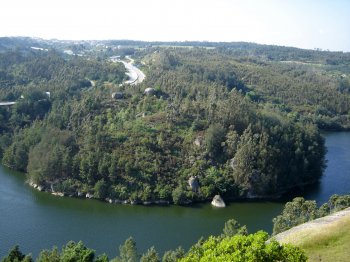
Miradouro Pedra da Sé
- country
- leisure
Tábua
3420, Tábua
This viewpoint is located on the edge of the municipality, on one of the slopes that leads to the Aguieira reservoir. From the granite boulders of Pedra da Sé, you can enjoy magnificent views of the reservoir.
Parque Catarina Eufémia
- country
- leisure
Avenida Alfredo da Silva
2830, Barreiro
A well taken care of large garden with flowerbeds, lawns, a pigeon house and the statue of Alfredo da Silva. In a small island on the lake theere is a cafe. It is a pleasant leisure area.
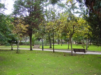
Jardim da Senhora A Branca
- country
- leisure
Largo Senhora-a-Branca
4710-926, Braga
Almost a continuation of the Jardim da Avenida Central (Garden of the Central Avenue). Enjoy the pleasure of sitting on one of the garden benches and admiring the surrounding sceneries, typical of the city of Braga.
Miradouro da Vigia da Baleia
- country
- leisure
ER 1-2
9580-228, Vila do Porto
Location offering a beautiful view over the entire neighbouring region and especially on the sea. In the background you can see the Farol da Maia, deployed on the hill with the same name.
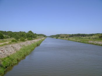
Rio Vizela
- beach
- country
Rio Vizela
4795, Aves
The Vizela river flows to the southwest until quite near the parish of Jugueiros and then heads west. It has its mouth 1 km away from Vila das Aves.
Foz do Rio Liz
- beach
- country
Foz do Rio Liz
2430, Vieira de Leiria
This river, which originates in Fontes, bathes the city of Leiria and flows into the Atlantic Ocean, north of Praia da Vieira, parish of Vieira de Leiria, municipality of Marinha Grande.
Percurso Pedestre da Aldeia de Montesinho
- country
Largo da Roçada (junto ao edifício da Casa do Povo)
5300, Montesinho
A circular pedestrian trail where one may visit the Fraga do Cucu, that brings to mind the image of a bird standing on a rock, the Cortelhos bridge, the alto das Barreiras, where the population took refug during the French invasions. It also passes by a unique nature built place, where the rocks sculpt curious ffects on the water. It is recommended that one takes this trail in the springtime of in the fall.
Trilho do Agrião (PR12)
- country
Rua Gonçalo Velho
9650-411, Povoação
This pedestrian path starts in Ribeira Quente and ends in the village, with a duration of about three hours. The path is primarily along the coast, passing through woods of frankincense, Acacia and vinháticos, some pastures, the Lomba of Knight, an old mill and iron bridge. Highlighting a viewpoint from where you can see the Graminhais, the Pico da Vara, Pico Bartolomeu and the seven speed bumps of the village.
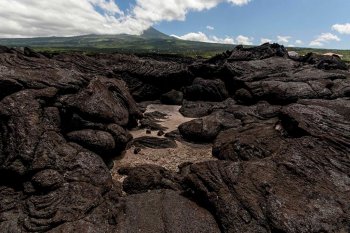
Paisagem Protegida do Lajido de Santa Luzia
- country
Lajido
9940-108, Madalena
The Pico Island Vineyard Culture Landscape is made up of Lajido da Criação Velha and Lajido de Santa Luzia, occupying a total of 154 hectares. These sites constitute excellent representations of traditional architecture, landscape design and natural elements, located on extensive lava fields. Since 2004, the vineyard landscape on the island of Pico has been classified by UNESCO as a World Heritage Site.