Explore the best places
Results for Serra+da+Estrela in Portugal
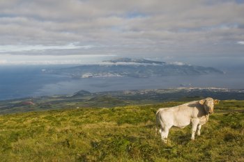
Miradouro de Cabeço das Cabras
- country
- leisure
Madalena
9950-364, Madalena
Cabeço das Cabras constitutes the final frontier between the adventurous who set out for the mountain and the more fearful who prefer the safety of the road. Located at an altitude of approximately 1,200 meters, on the western slope of Pico Mountain, it is the highest point on the island accessible by car. From here, one can see the entire island of Faial and the vast blue sea.
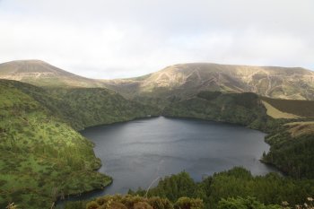
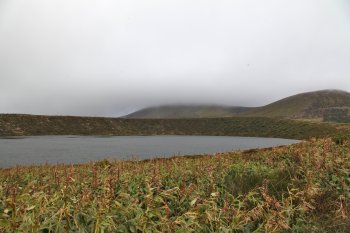
Lagoa Funda
- beach
- country
Lagoa Funda
9970-265, Lajes das Flores
This is one of the many lagoons on the island of Flores. It belongs to the group of Seven Lagoons that were formed in seven volcanic craters caused by the eruptions that gave rise to the island. The remaining lagoons in this group are Lagoa Branca, Lagoa Comprida, Lagoa Rasa, Lagoa da Lomba, Lagoa Negra and Lagoa Seca. It is surrounded by mountains and Laurissilva forests, which give it a unique environment.
Fonte Arcada
- country
- heritage
Fonte Arcada
3640, Fonte Arcada
A typical village on the right bank of the Távora river, with traditional houses and granite cobblestone streets. A special note to the romanesque church, restored in the 16th century, a romanesque fountain, the House of Paço, with a gothic portal, the Fountain of Mergulho, with a granite barrel vault and the Place of the Toca da Moura (The Moor Woman's Lair), a natural shelter. It has astounding views of the village and of the dam from a belvedere.
Pitões das Júnias
- country
- heritage
Pitões de Júnias
5470, Pitões de Júnias
In this traditional village of the Lands of Barroso, one can still view typical cul covered houses. A special note to the church and the ruins of the beneditin convent of Saint Maria, a national monument, whose existence may date back to the 9th century and still has the romanesque portico of the old church by the convent. Near Pitões das Júnias there is a natural waterfall of rare beauty.
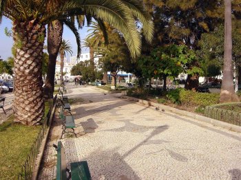
Jardim Manuel Bívar
- country
- leisure
Praça Dom Francisco Gomes, 12
8000-269, Faro
Garden with different types of trees and well-designed and arranged flower beds, interspersed with long cobbled corridors that invite you to take a walk. There is also a small café with a pleasant terrace. Even before the 17th century it contained important buildings such as the Hospital and Igreja da Misericórdia, and during the 17th and 19th centuries the Customs and Civil Government buildings were built here.
Lagoa Rasa
- beach
- country
Lagoa Rasa
9970-265, Lajes das Flores
This is one of many existing ponds on the island of Flores. Belong to the set of Seven Lakes that were formed into seven volcanic craters caused by the eruptions that gave rise to the island. The remaining ponds of this set are the White Pond, Long Pond, Black Lagoon, Lagoa da Lomba, Deep lagoon and the Lagoa Seca. It is located at an average height of 600 metres above sea level.
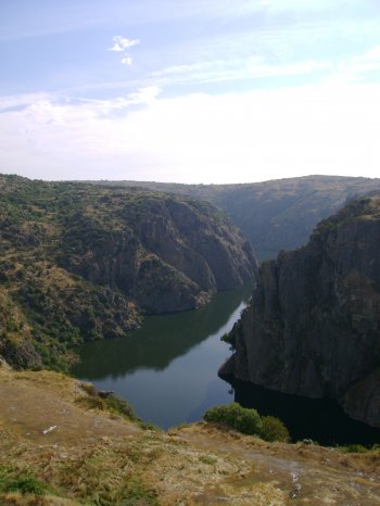
Parque Natural do Douro Internacional
- country
Rua Dr. Francisco António Vicente, 4
5200-241, Mogadouro
Integrating the municipalities of Figueira de Castelo Rodrigo, Freixo de Espada-à-Cinta, Miranda do Douro and Mogadouro, the Douro Internacional Natural Park covers the 122 kilometers of border section of the Douro River and extends south, to the Douro Valley. From a very deep valley and two plateau areas (essentially granite), one to the North with altitudes of around 700-800 meters and the other to the South with altitudes of around 600-700 meters. The gorges carved by the Douro and Águeda rivers are extremely deep (up to 200 meters) and of great beauty. The Park reaches its maximum altitude (895 meters) …
Vila da Ponte
- country
- heritage
Vila da Ponte
3640, Vila da Ponte
Located on the banks of the Távora river, Vila da Ponte, the "Pearl of Távora", is famed for its traditional small river fishes. This village has about 700 inhabitants who are mostly farmers and cattle raisers. Theere are also small firms. The roman bridge on the Távora is about 50 metres long and stands on four arches. The 17th century pillory signals the turning to a parish siege in 1661.
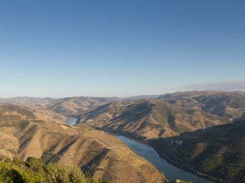
Miradouro de São Leonardo da Galafura
- country
- leisure
Galafura
5050, Peso da Régua
Between Peso da Régua and Pinhão, exit at Covalinhas to reach the top of São Leonardo and its chapel. From this site, known for having inspired Miguel Torga, you can glimpse the Douro Valley. The river, far below, flowing slowly toward its mouth, the rugged slopes and sharp peaks, and the verdant greenery of the nearby vineyards, which try to disguise the prevailing grayness.
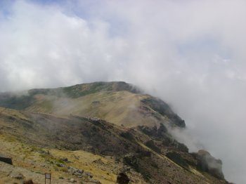
Miradouro do Pico do Areeiro
- country
- leisure
Pico do Arieiro
9230-212, São Roque do Faial
It is the second-highest peak on the island of Madeira, with an altitude of 1818 meters. It offers a magnificent view and, when the weather is good, you can see the neighboring island of Porto Santo. It has an inn, a restaurant and a souvenir shop and is one of the most visited peaks on the island due to good access and the trails that connect it to Pico das Torres and Pico Ruivo, which are very well-prepared and signposted.